Building Your Own World with High-Resolution Watercolor Map Elements
There is a distinct charm to hand-painted illustrations that digital vectors often struggle to replicate. The subtle bleed of pigment, the organic texture of the paper grain, and the soft edges of a watercolor wash bring a sense of warmth and nostalgia to any project. For designers, game masters, and content creators looking to infuse their work with this specific aesthetic, having access to a comprehensive library of assets is invaluable. This is where a collection like the Cute Travel Map - Watercolor Clip Art set becomes a transformative tool, offering not just images, but the building blocks for entire worlds.
When embarking on a creative project involving maps, whether for a tabletop role-playing game, a wedding invitation suite, or a children's book, the devil is truly in the details. A generic map template might suffice for a quick draft, but it rarely captures the unique personality of a specific story or brand. By utilizing isolated, high-quality elements, creators gain the freedom to construct scenes that are entirely their own. The versatility of such a kit lies in its modularity; you aren't stuck with a pre-drawn landscape. Instead, you receive the raw materials—trees, mountains, rivers, and structures—to paint your own narrative visually.
The Power of Isolated Elements in Design Workflows
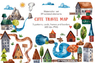
The core of this collection consists of 89 watercolor isolated elements, all provided as PNG files with transparent backgrounds. This technical specification is crucial for modern design workflows. A transparent background means these assets can be layered over any color, texture, or existing map base without unsightly white boxes or jagged edges surrounding them. Furthermore, the resolution of 600 dpi ensures that every brushstroke remains crisp, even when printed on large formats or viewed on high-definition screens.
Consider the natural landscape components included in the set. With 24 unique trees, 3 bushes, and 7 bunches of grass, a designer can create forests that look varied and organic rather than repetitive. In nature, no two trees are identical, and a good map should reflect that randomness. By mixing and matching these different silhouettes, you avoid the "stamped" look that plagues lower-quality clip art. Similarly, the geological features—comprising 2 pieces of land, 2 hills, 2 mountains, and even a singular volcano—allow for the construction of diverse terrains. Whether you are mapping a gentle rolling countryside or a dangerous volcanic region, these elements provide the necessary topographical variety.
Water bodies are equally well-represented, featuring 3 rivers and 2 lakes. These are essential for guiding the viewer's eye across a map and establishing logical settlement patterns, as civilizations historically flourish near water sources. The inclusion of 3 stones adds those final touches of realism to riverbanks or mountain paths, breaking up uniform lines and adding visual interest to empty spaces.
Constructing Narratives with Architectural Assets
A map tells a story not just through its geography, but through its inhabitants and their structures. This watercolor set excels in providing a wide array of architectural options. The collection includes 11 houses, which likely vary in style and size, allowing for the creation of bustling villages or solitary homesteads. For more grandiose settings, the inclusion of a fortress and a tower offers immediate focal points for adventure or conflict in a gaming scenario.
Temporary or travel-specific structures are also covered, such as a tent, perfect for marking a campsite or a nomadic route. The attention to detail extends to smaller architectural components like 2 roofs and a pipe, which can be used to customize buildings further or create unique composite structures. Defensive and boundary markers are present as well, with 2 pieces of fence and 2 flags helping to define territories, property lines, or faction control zones on a strategic map.
Navigation is a key theme in travel maps, and this kit supports that function beautifully. It includes 7 road pieces that can be connected to form winding paths, highways, or dirt trails. To ensure travelers (or players) know where they are going, the set provides 3 signposts and a stick that can serve as a marker. For emphasizing specific locations or objectives, the inclusion of a big red arrow and a big red heart allows creators to highlight points of interest, quest targets, or beloved destinations directly on the map interface.
Atmospheric Details and Seamless Patterns
No landscape feels alive without the atmosphere surrounding it. The sky and weather elements in this collection help set the mood. With 4 clouds, a radiant sun, and even a smoke cloud (perhaps rising from a chimney or a distant fire), artists can add depth and temporal context to their scenes. Is a map set during a bright, sunny day? Or is there smoke on the horizon suggesting a nearby settlement or danger? These small additions make a significant difference in immersion.
Beyond individual objects, the set offers extensive resources for backgrounds and framing through its pattern library. There are 5 seamless, tileable patterns available in two distinct sizes: a regular version at 4000 x 4000 px and a massive large version at 8000 x 8000 px. Both maintain the high 600 dpi standard. Seamless patterns are critical for creating infinite backgrounds or filling large areas without visible repetition seams. Whether used as the ocean surface, a parchment texture for the map background, or a decorative border fill, these high-resolution tiles ensure professional quality regardless of the output size.
For those who prefer a head start or need inspiration, the collection includes 21 composed images made from the basic elements. These pre-assembled scenes demonstrate how the individual assets can be combined effectively, serving as excellent references for layout and composition. Additionally, the set provides structural aids for presenting the final map, including 7 borders, 5 frames, and 9 cards. These elements are perfect for packaging the map into a finished product, such as a greeting card, an invite, or a handout for a game session.
Practical Applications Across Industries
The utility of the Cute Travel Map - Watercolor Clip Art extends far beyond a single niche. In the realm of Tabletop Role-Playing Games (TTRPGs), Game Masters constantly need fresh visuals to engage their players. Instead of drawing every session's location from scratch or using generic digital tokens, a GM can assemble custom battle maps or world overviews in minutes. The high resolution ensures these maps look great when projected on a screen or printed as handouts.
In the wedding and event industry, illustrated maps are a trending way to guide guests to venues, especially for destination weddings or large estates with multiple ceremony and reception sites. The hand-painted aesthetic fits perfectly with rustic, bohemian, or whimsical wedding themes. Using the houses, trees, and roads from this set, a designer can create a charming "journey to love" map that doubles as a keepsake for guests.
Educators and authors also find immense value in such resources. Children's books often rely on illustrated maps to help young readers visualize the story's setting. The cute, approachable style of watercolor makes these maps inviting rather than intimidating. Similarly, history teachers can use these elements to create engaging visual aids that explain historical routes, settlements, or geographical changes without the sterile look of textbook diagrams.
Technical Considerations and Quality Assurance
When investing in digital assets, quality assurance is paramount. The specification of PNG format with transparent backgrounds is the industry standard for a reason; it preserves quality and allows for non-destructive editing. Unlike JPEGs, which introduce compression artifacts and solid backgrounds, PNGs ensure that the delicate watercolor textures remain clean. The 600 dpi resolution is particularly noteworthy. Most screen-based graphics hover around 72 to 150 dpi, while standard print is 300 dpi. Providing assets at 600 dpi gives users the flexibility to scale images down for sharpness or print them at very large sizes without losing detail. This future-proofs the investment, allowing the assets to be used for everything from small web icons to large-format posters.
The sheer volume of the collection—nearly 90 isolated elements plus patterns and compositions—offers a high return on investment. It eliminates the need to hunt for disparate assets from different artists, which often results in clashing styles and inconsistent lighting. Having a cohesive set where the trees, mountains, and houses all share the same artistic DNA ensures that the final composition looks unified and professional.
Ultimately, the value of this watercolor clip art set lies in the balance it strikes between convenience and creativity. It removes the barrier of needing advanced illustration skills to create beautiful maps while retaining the artistic soul of hand-painted media. Whether you are a professional graphic designer looking to speed up your workflow, a hobbyist creating a fantasy world for friends, or an entrepreneur designing branded merchandise, these elements provide the foundation for limitless creative expression. The ability to mix, match, and layer these high-fidelity assets empowers users to tell their stories with clarity, charm, and a touch of artistic elegance.